Definition of agroclimatic zone
An agro-climatic zone is a land unit uniform in respect of climate and length of growing period (LGP) which is climatically suitable for a certain range of crops and cultivars (FAO, 1983).
Classification of agroclimatic zone
Planning Commission of India (1989) made an attempt to delineate the country into different agroclimatic regions based on homogeneity in rainfall, temperature, topography, cropping and farming systems, and water resources.
Agroclimatic zones of India
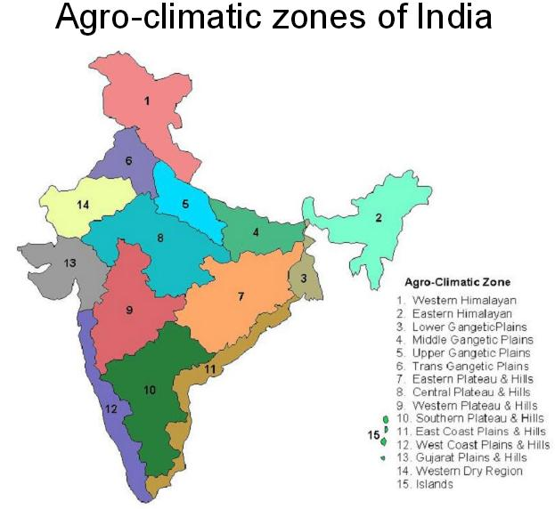
India is divided into 15 agro-climatic regions they are
- Western Himalayan Zone
- Eastern Himalayan Zone
- Lower Gangetic Plains Zone
- Middle Gangetic Plains Zone
- Upper Gangetic Plains Zone
- Trans-Gangetic Plains Zone
- Eastern Plateau and Hills Zone
- Central Plateau and Hills Zone
- Western Plateau and Hills Zone
- Southern Plateau and Hills Zone
- East coast plains and Hills Zone
- West coast plains and Hills Zone
- Gujarat plains and Hills zone
- Western Dry zone
- Island zone
Agroclimatic zones of India in detail
1. Western Himalayan zone
This zone consists of three distinct sub-zones of Jammu and Kashmir, Himachal Pradesh and Uttar Pradesh hills. The region consists of skeletal soils of cold region, podsolic mountain meadow soils and hilly brown soils. Lands of the region have steep slopes in undulating terrain. Soils are generally silty loams and these are prone to erosion hazards.
2. Eastern Himalayan zone
Sikkim and Darjeeling hills, Arunachal Pradesh, Meghalaya, Nagaland, Manipur, Tripura, Mizoram, Assam, and Jalpaiguri and Coochibihar districts of West Bengal fall under this region, with high rainfall and high forest cover. Shifting cultivation is practiced in nearly one-third of the cultivated area and this has caused denudation and degradation of soils with the resultant heavy runoff, massive soil erosion, and floods in lower reaches and basins.
3. Lower Gangetic Plains zone
This zone consists of the West Bengal-lower Gangetic plain region. The soils are mostly alluvial and are prone to floods.
4. Middle Gangetic Plains zone
This zone consists of eastern Uttar Pradesh and Bihar plains. This zone has a geographical area of 16 million hectares and rainfall is high. About 39% of the gross cropped area is irrigated and the cropping intensity is 142%.
5. Upper Gangetic Plains zone
This zone consists of around 32 districts of Uttar Pradesh. Irrigation is through canals and tube wells. Good potential for exploitation of groundwater exists.
6. Trans-Gangetic Plains zone
This zone consists of Punjab, Haryana, the Union territories of Delhi and Chandigarh and the Sriganganagar district of Rajasthan. The major characteristics of this area are the highest net sown area, highest irrigated area, high cropping intensity, and high groundwater utilization.
7. Eastern Plateau and Hills zone
This zone consists of eastern part of Madhya Pradesh, southern part of West Bengal and most of inland Orissa. The soils are shallow and medium in depth and the topography is undulating with a slope of 1-10%. Irrigation is through tanks and tube wells.
8. Central Plateau and Hills zone
This zone comprises of some districts of Madhya Pradesh, part of Uttar Pradesh and Rajasthan. The topography is highly variable nearly 1/3rd of the land is not available for cultivation. Irrigation and cropping intensity are low. 75% of the area is rainfed grown with low value cereal crops. There is an intensive need for alternate high value crops including horticultural crops.
9. Western Plateau and Hills zone
This zone comprises the major part of Maharastra, parts of Madhya Pradesh, and one district of Rajasthan. The average rainfall of the zone is 904 mm. The net sown area is 65% and forests occupy 11%. The irrigated area is only 12.4% with canals being the main source.
10. Southern Plateau and Hills zone
This zone comprises Andhra Pradesh, Karnataka and Tamil Nadu which are typically semi-arid zones. Dryland farming is adopted in 81% of the area and the cropping intensity is 111 percent.
11.East Coast Plains and Hills zone
This zone comprises of east coast of Tamil Nadu, Andhra Pradesh, and Orissa. Soils are mainly alluvial and coastal sands. Irrigation is through canals and tanks.
12. West Coast Plains and Ghats zone
This zone comprises west coast of Tamil Nadu, Kerala, Karnataka, Maharastra, and Goa with a variety of crop patterns, rainfall, and soil types.
13. Gujarat Plains and Hills zone
This zone consists of 19 districts of Gujarat. This zone is arid with low rainfall in most parts and only 32.5% of the area is irrigated largely through wells and tube wells.
14. Western Dry zone
This zone comprises nine districts of Rajasthan and is characterized by hot sandy desert, erratic rainfall, high evaporation, and scanty vegetation. The groundwater is deep and often brackish. Famine and drought are common features of the region.
15. Islands zone
This zone covers the island territories of Andaman and Nicobar and Lakshadeep which are typically equatorial with rainfall of 3000 mm spread over eight to nine months. It is largely a forest zone with undulated lands.
Jal shakti department official link
Critical stage of irrigation of crops
Useful research paper for this article Agroclimatic zones of India based research paper
Agroclimatic zones of india FAQ
Number of agroclimatic zones in India
15
Factors determining agroclimatic zone
climate and length of growing period

